OVERVIEW
Taught by faculty and industry-recognized experts, the Smart Cities U noncredit certificate is designed to meet the needs of anyone looking to benefit their community, particularly on-the-ground practitioners in small to midsize communities with fewer than 500,000 residents.
Enjoy the convenience of learning from anywhere. You will learn about smart city development planning, including the importance of collaboration amongst stakeholders, through case studies, activities, and additional resources. These sessions are helpful for non-government and government organizations, including individuals looking to do business with governmental organizations.
AVAILABLE FOCUS AREAS
Smart Cities U is constructed with specialized certificates in different smart cities topics, allowing participants the ability to partake in their area of greatest need. Each topic has three separate workshops focusing on the following components: assessment, government capacity, and action planning. Participants have to partake in all three workshops of that specialty topic to receive the certificate and shareable digital badge. Introductory sessions to accompany certificates are also available.
Smart Mobility Certificate
Smart Infrastructure Certificate
Smart Security Certificate
INTRODUCTORY
SESSIONS
Mar 24, 2022
Smart Cities and Economic Development | Mar 24 | 9-10:30 AM
Overview of Smart Cities and how it links to Economic Development
Overview of Smart Cities and how it links to Economic Development Economic development is a number one concern for municipalities, as a means to increase the well being of their citizens and successful economic development depends on collaborative planning, funding, and implementation. This session will identify trends in economic development in small to midsize communities, suggest timelines for development, and tie in smart city tactics to the overall strategic plan. Selected Smart city approaches, technology based and non- technology based, will be presented and discussed.
Learning Objectives
- You will identify key areas of opportunity for economic development for small to midsize communities in the Midwest region, and the ways in which smart city planning ( and technology) can bolster economic development.
- You will develop a smart economic development strategy based on one identified priority for their community.
Target Audience
- All government officials
- Private corporations
- Non-profit organizations
- Investment/ development funds
Smart City Readiness | Mar 24 | 10:45 AM-12:15 PM
Are You Smart City Ready?
In trying to answer if your community is “smart city” ready, you likely began to think a lot about WiFi, IoT, and other technologies. But being ready for a successful smart city project is actually a process, not a single answer. And the first step begins not with technology, but with a basic question, “what does my community need?” This session will introduce an approach to thinking about smart cities projects that can help participants define, scope, fund, and manage smart cities projects. By bringing a structured approach to the problem, participants may find that they can often uncover new means of funding, new technologies, and even new ways of solving citizens’ problems that they may have missed before.
Learning Objectives
- You will develop concept plans for economic competitiveness appropriate to their municipality.
- You will evaluate their ability to develop a business model with emphasis on funding and innovative financing.
Target Audience
- All government officials
- Private corporations
- Non-profit organizations
- Investment/ development funds
Data Embedded Decision Making | Mar 24 | 1:15-2:45 PM
DATA EMBEDDED DECISION MAKING: Aligning Decisions with Data
Ray Roberts, a data scientist and impact solutions consultant, provides data tactics to move through the stages of interpreting underlying patterns that provide both insights into the problems at hand, and the capacities to provide solutions. Readiness assessment enables us to take progressive steps that factor in newly acquired knowledge from previous steps. We will take a journey of assessing 1.) ourselves, 2.) our question, 3.) our cost of no answer, 4.) our cost to acquire the answer, and 5.) our expected gain of an answer. The intent is to take an honest look of not just what we are asking for, but internally at ourselves as to whether we really want it, and should we really be asking for it. The alignment of outcomes with intentions is the ultimate metric for Data Science initiatives. This approach aims to provide a methodology framework (Data Embedded Decision Making) with processes and measurements that are tool-agnostic, purposed to close the space between the outcomes and intentions.
Learning Objectives
- Analytical Ask Construct: Do you have a historical, diagnostic, predictive or prescriptive question?
- Data Maturity Assessment: Given the ""level of analytical ask"", what resources are recommended? do you have them?
- Cost Pareto: Given a list of different analytical asks, what is the relative ""pain"" for not having them answered?
- Estimated Benefit Analysis: What is our assessment of the gain for having the questions answered (with our solution)?
Target Audience
- All government officials
- Private corporations
- Nonprofit organizations
- Investment/ development funds
SMART
MOBILITY
Mar 31, Apr 7, Apr 14, 2022
Where you are and where you want to be | Mar 31 | 9-10:30 am
SMART MOBILITY: Baseline analysis of need, equity gaps, economic/social opportunities
Kenny French, Ph.D., Associate Professor of Geography and Geographic Information Systems at the University of Wisconsin-Parkside, will take you through using GIS (Geographical Information Systems), baseline datasets can be created for planning purposes. Baseline analysis will include data collection resources, data preparation, data modeling, and result presentation. GIS is one of the tools through which governments can integrate multiple characteristics of their community in a spatial context, determining the scope and intensity of need. Clear presentation of results, which is imperative to any consensual decision-making process, will be described and samples provided. Selected mobility related variables will be discussed such as multi modal mobility patterns (including pedestrian), stress points or gaps in the mobility framework, and the integration of demographic characteristics and the impact on the planning process.
Learning Objectives
- You will become familiar with using data visualization methods, such as GIS, to assess and evaluate existing needs in their community.
- You will construct baseline models by selecting variables most important to the transportation needs of their community.
- You will identify publicly available data sources for assessment.
Target Audience
- All government officials
- Private corporations
- Nonprofit organizations
- Investment/ development funds
- Individuals in transportation planning
- Transportation specialists: managers, planners, mobility corridor planners, transportation safety and control
Measuring Readiness | April 7 | 9-10:30 am
SMART MOBILITY: Utilizing readiness tools to analyze your community and municipality
Ray Roberts, a data scientist and impact solutions consultant, will take a deeper dive into readiness assessment using data to understand challenges and opportunities in the transportation sector. Using DEDM (Data Embedded Decision Making) participants will work with transportation-oriented development readiness tools to determine what measures make the most sense for their region, and how to interpret readiness without needing to hire a data scientist. This session builds on the first session in this track which provided skills for baseline assessment in the transportation area. In this workshop, we will share selected readiness tools that can be used to assess political, economic, and social resources to launch a smart mobility initiative.
Learning Objectives
- You will analyze and compare readiness tools and apply to their local context.
- You will recognize the benefits of collaboration with various stakeholders, such as government, business, university, and community, in readiness assessment and how to put a plan in place to work together.
Target Audience
- All government officials
- Private corporations
- Nonprofit organizations
- Investment/ development funds
- Individuals in transportation planning
- Transportation specialists: managers, planners, mobility corridor planners, transportation safety and control
Action Plan/ Case Study | April 14 | 9-10:30 am
SMART MOBILITY: Successful readiness assessment and project launch
In this session with William Martin, you will do a deeper dive into a successful readiness assessment and project launch in a small to midsize municipality. The City of Racine, as part of Smart Racine efforts, is pioneering the introduction and integration of an autonomous vehicle (AV) shuttle into public transportation systems in Wisconsin. The Racine AV shuttle, known as the “Badger”, represents the first municipal AV deployment in Wisconsin and heralds the future of transportation: automated, connected, electrified and shared. As such, Racine AV provides a unique opportunity for the citizens and businesses of Racine and throughout Wisconsin to personally experience AV transportation, explore the positive impact of its implementation, and envision the many benefits that follow along. This session will explore the readiness assessments for the project, and the potential for technology transfer of an AV into smaller, regional communities.
Learning Objectives
- You will investigate the possibilities of similar projects in their municipalities.
- You will appraise the case study components in light of their utility in their own local context.
- You will assemble a list of questions needed to evaluate their own readiness to develop a smart mobility project
Target Audience
- All government officials
- Private corporations
- Nonprofit organizations
- Investment/ development funds
- Individuals in transportation planning
- Transportation specialists: managers, planners, mobility corridor planners, transportation safety and control
SMART INFRASTRUCTURE
Mar 31, Apr 7, Apr 14, 2022
Where you are and where you want to be | Mar 31 | 10:45 AM-12:15 PM
SMART INFRASTRUCTURE: Baseline analysis of need, equity gaps, economic/social opportunities
Kenny French, Ph.D., Associate Professor of Geography and Geographic Information Systems at the University of Wisconsin-Parkside, will take you through using GIS (Geographical Information Systems), baseline datasets can be created for planning purposes. Baseline analysis will include data collection resources, data preparation, data modeling, and result presentation. GIS is one of the tools through which governments can integrate multiple characteristics of their community in a spatial context, determining the scope and intensity of need. Clear presentation of results is imperative to any consensual decision-making process. Selected infrastructure related objects will be discussed such as roadways, health facilities, schools, and housing, and the integration of demographic characteristics.
Learning Objectives
- You will become familiar with using data visualization methods, such as GIS, to assess and evaluate existing needs in their community.
- You will construct baseline models by selecting variables most important to the infrastructure needs of their community. You will identify publicly available data sources for assessment.
Target Audience
- All government officials
- Private corporations
- Nonprofit organizations
- Investment/ development funds
- Public works departments: Infrastructure, Energy, Environment Capability/Solutions
Measuring Readiness | April 7 | 10:45 am-12:15 pm
SMART INFRASTRUCTURE: Utilizing readiness tools to analyze your community and municipality
Ray Roberts, a data scientist and impact solutions consultant, builds on the first which provided skills for baseline assessment in the infrastructure area. In this workshop, we will share selected readiness tools that can be used to assess political, economic, and social resources to launch a smart infrastructure initiative. Using DEDM ( Data Embedded Decision Making), 3 types of infrastructure readiness will be assessed:- the physical attributes of the community that provide the opportunities for economic development, the organizational characteristics of the government and associated stakeholders to implement any needed change, and the technological resources available to implement initiatives.
Learning Objectives
- You will comparatively assess readiness tools appropriate for three areas of infrastructure development- organizational capacity, technological capacity, and physical structures.
- You will prioritize the three areas of infrastructure readiness according to their local context.
Target Audience
- All government officials
- Private corporations
- Nonprofit organizations
- Investment/ development funds
- Public works departments: Infrastructure, Energy, Environment Capability/Solutions
Action Plan/ Case Study | April 14 | 10:45 am-12:15 pm
SMART INFRASTRUCTURE: Successful readiness assessment and project launch
In 2019, the City of Kenosha’s curb side collection consisted of approximately 31,700 users. The City has grown over the last 20 years but the number of waste collectors has remained constant, increasing both the number of collections and the weight per day per collector. This increase strained the City’s resources and required the Waste Division to evaluate its process. Shelly Billingsley, Director of Public Works, and Keir Powell, Kenosha’s Superintendent of Solid Waste Division, will present the decision making process leading to the modernization of waste collection to increase efficiency, reduce costs, and increase well-being of the community.
Learning Objectives
- Provide cities with an approach and lessons learned process on how change can happen and what can be done to turn things around
- Goal setting: Creating a place to live, work, and play and turning the vision into reality.
- Looking at approaches to gaining stakeholder input and buy-in.
Target Audience
- All government officials
- Private corporations
- Nonprofit organizations
- Investment/ development funds
- Public works departments: Infrastructure, Energy, Environment Capability/Solutions
SMART
SECURITY
Mar 31, Apr 7, Apr 14, 2022
Where you are and where you want to be | Mar 31 | 1:15-2:45 pm
SMART SECURITY: Baseline analysis of need, equity gaps, economic/social opportunities
Kenny French, Ph.D., Associate Professor of Geography and Geographic Information Systems at the University of Wisconsin-Parkside, will take you through using GIS (Geographical Information Systems), baseline datasets can be created for planning purposes. Baseline analysis will include data collection resources, data preparation, data modeling, and result presentation. GIS is one of the tools through which governments can integrate multiple characteristics of their community in a spatial context, determining the scope and intensity of need. Clear presentation of results is imperative to any consensual decision-making process. Selected security related variables will be discussed such as crime incidents, accidents, security monitoring systems, and the integration of demographic characteristics.
Learning Objectives
- You will become familiar with using data visualization methods, such as GIS, to assess and evaluate existing needs in their community.
- You will construct baseline models by selecting variables most important to the security needs of their community.
- You will identify publicly available data sources for assessment
Target Audience
- All government officials
- Private corporations
- Non profit organizations
- Investment/ development funds
- Security companies
- Law enforcement
- Judicial officers
- Attorneys
Measuring Readiness | April 7 | 1:15-2:45 pm
SMART SECURITY: Utilizing readiness tools to analyze your community and municipality
Ray Roberts will take a deeper dive into readiness assessment using data to understand challenges and opportunities in the security sector. Technology can increase efficiency and effectiveness of law enforcement in communities; participants will prioritize needs according to incident data, and will develop a tool to connect readiness of police, community, and government to implement technology based solutions. Building on the baseline analysis this session will review various tools to assess select safety concerns, including criminal activity, pedestrian safety, and police training. Using the Data Embedded Decision Making framework, participants will integrate community and equity considerations into policy decisions.
Target Audience
- All government officials
- Private corporations
- Non profit organizations
- Investment/ development funds
- Security companies
- Law enforcement
- Judicial officers
- Attorneys
Action Plan/ Case Study | April 14 | 1:15-2:45 pm
SMART SECURITY: Successful readiness assessment and project launch
Gateway Technical College is expanding capacity in Virtual Reality simulations in police trainings to assist officers in developing appropriate tactical responses to deescalate crisis situations. Jimmie Spino, Instructor and Law Enforcement/Range Master for the Law Enforcement Academy at Gateway Technical College and Richard Stein, Director of Law Enforcement Training for the Protective Services Admin at Gateway Technical College, will share Gateway’s Multiple Interactive Learning Objectives (MILO) training system, a 360-degree simulator, along with an assessment as to why it was needed, its challenges and advantages for the police and the public. The degree of community input and the law enforcement response will be considered. They will also share a new 4-D training experience that they are currently implementing that will be available to the public to experience.
Learning Objectives
- Provide a basis for understanding and applying alternative policing scenarios.
- Understanding crowd de-escalation techniques and how to apply them.
- Understanding the challenges between policing and prosecution of criminal activities.
Target Audience
- All government officials
- Private corporations
- Non profit organizations
- Investment/ development funds
- Security companies
- Law enforcement
- Judicial officers
- Attorneys
PRICING AND REGISTRATION
INTRODUCTORY SESSIONS
Included at no cost when registering for one or more certificates
Private Sector | $99
Nonprofit/Public Sector | $79
INDIVIDUAL CERTIFICATES
Includes introductory sessions
Private Sector | $495
Nonprofit/Public Sector | $350
ALL THREE SPECIALIZATIONS/CERTIFICATES
Includes introductory sessions
Private Sector | $1295
Nonprofit/Public Sector | $999
Student | $499*
*Scholarship available for UW-Parkside students
Ready to enroll? Build your Smart Cities U registration today!
ABOUT THE INSTRUCTORS
-
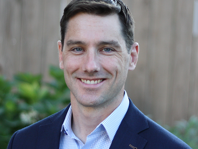
Joe Mariani
Joe Mariani is a Kenosha resident and research manager with Deloitte’s Center for Government Insights. His research focuses on innovation and technology adoption for both national security organizations and commercial businesses. His previous work includes experience as a consultant to the defense and intelligence industries, high school science teacher, and Marine Corps intelligence officer.
-

Dr. Kenny French
Dr. Kenny French, Associate Professor of Geography and Geographic Information Systems at the University of Wisconsin Parkside, specializes in urban planning and transportation applications. Dr French teaches geography of transportation and land use planning.
-
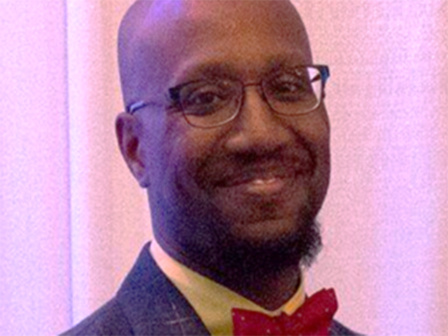
Ray Roberts
Starting his professional career in the US Military, Raymond completed his military service as an infantry officer. Raymond transitioned out of the military into project management and investment management in 2010. Noticing the trends of analytics taking prominence, Raymond continued his education in economics and data science through the University of Wisconsin System (Parkside, Whitewater, and Oshkosh campuses). Raymond is currently a Staff Data Scientist General Electric Healthcare as a leader in their Self-Healing Machine initiatives. Raymond is married to Jordania Leon-Jordan and they live in Kenosha, WI, where Jordania is the CIO at UW-Parkside and a professor of project management. They have three boys: Ray, Luke, and Santiago with their daughter Sirma who just achieved the feat of 18 months old recently. Raymond’s hobbies include musical instruments, writing and languages.
-

Dr. Peggy James
Dr. Peggy James, Dean and Professor at the University of Wisconsin Parkside, has published on smart cities and civic technology. She currently teaches courses on strategic and tactical decision making. She has coauthored work with William Martin on the initial steps of Racine Wisconsin towards becoming a smart city.
-
William Martin
William Martin, CEO of Badger Development , former CIO of Racine Wisconsin, was the lead member of Racine’s team when it received the Smart City Designation from the Smart Cities Council in 2019, the smallest city to receive that designation nationally.
-
Shelly Billingsley
Shelly Billingsley is the Director of Public Works for the City of Kenosha. Shelly has 19 years of experience working with the City. She specializes in engineering and management principles and spent her first year, with the City, analyzing the Waste Division for efficiencies. She graduated from UW-Milwaukee with a Civil Engineering Degree in 2000 and UW-Parkside with a Masters in Business Administration in 2014. While at the City she was featured in She Magazine and in 2016 she won the Women in Construction award. Shelly is inspired daily by her husband and their daughter and son. In her free time she likes to spend time on their hobby farm, crocheting, drawing, and her family.
REQUEST INFO
Requirements
Zoom
Prerequisites
There are no prereqs but it is intended for all government officials, private corporations, non-profit organizations, investment/ development funds
The University of Wisconsin-Parkside is committed to providing access, equal opportunity, and reasonable accommodation in its services, program activities, education, and employment for individuals with disabilities. To request disability accommodations, contact Professional and Continuing Education at least eight weeks in advance at: 262-595-3340 (V), 262-595-2513 (FAX), or email continuing.ed@uwp.edu.